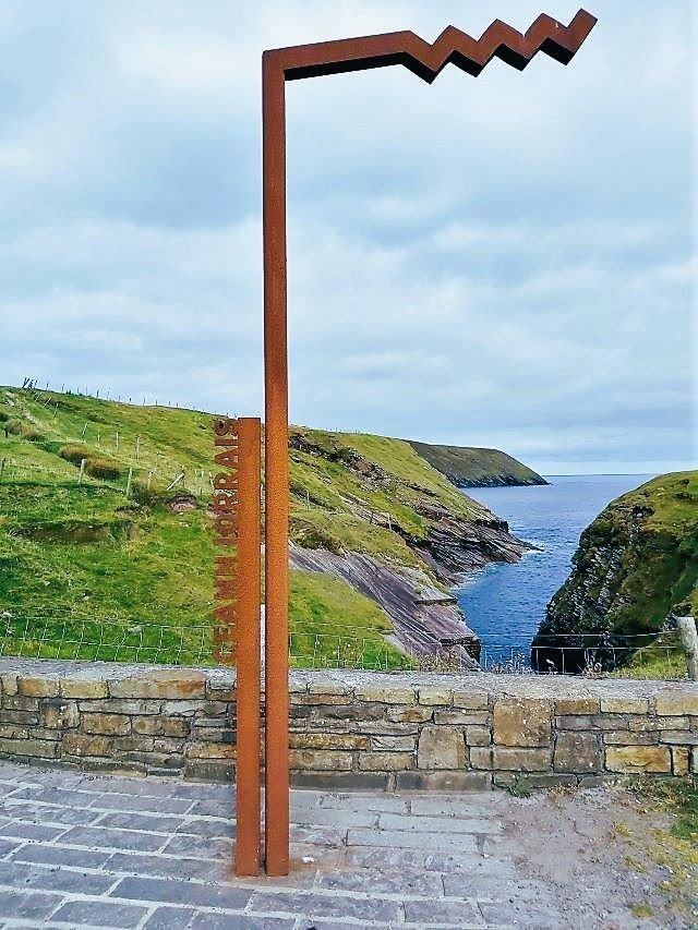
As we have written previously, we love County Mayo. The Erris Head Loop Walk is easily one of our favourite hikes in the area. Not only because it is a relatively easy three miles (five kms) but mainly for the incredible views. Erris Head, or Ceann Iorrais in Irish, is the northernmost tip of the Mullet Peninsula. You can only walk around it crossing the fields as there are no roads, which is cool.
Any time we were on the trail, it was quiet. We were never completely on our own, we met and saw in the distance a few other parties of walkers or anglers. But nothing like the crowds at the Cliffs of Moher. Erris Head is a true off-the-beaten-track gem. It’s spectacular views will take your breath away and make you wish you lived in North Mayo.
Do I Need Any Special Equipment?
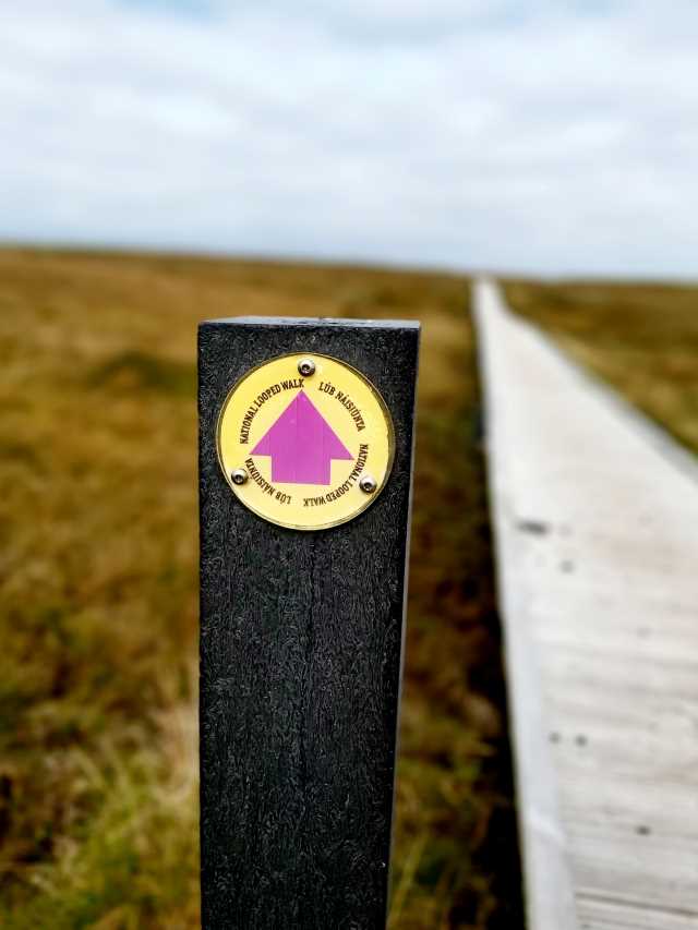
As always, dress according to the weather and your ability. Some of the trail is boggy and there are raised boardwalks to avoid the soggiest parts. Therefore, hiking boots are advisable, especially if the weather had been wet. I put mine on but did not actually need them as the day was overcast but dry. My husband did not bother with his at all.
Other than that you don’t need anything special with you. Sure, you can bring water and snacks. And if you have binoculars and a camera, they will come in handy, but they are not necessary to experience and enjoy the walk. Be prepared to cross a number of stiles as well as a wooden bridge. Nothing strenuous though. Most of the trail is either flat or has a gentle rise/slope.
How Long Does The Erris Head Loop Walk Take And Is It Suitable For Children?
You should allow cca two hours to complete the trail at a leisurely pace. If you are like us, you will be doing at least as much stopping, photo taking and views admiring as walking. It is a nature trail, so you would not be able to push a pram here, but older children who can manage the distance will be fine. Do keep an eye on them close to the cliff edges, they are high and unprotected. You will meet many, many sheep along the trail. These gentle creatures by and large mind their own business and leave humans alone.
Where Does The Walk Start?
The trail begins at a picturesque, sheltered cove with a curious name, the Danish Cellar. Out of interest, we tried to search its etymology. It remains obscure even though it has been used on maps since as early as 1837. There seems to be no connection with Denmark, the Vikings or the Danish people, though, as one might (mistakenly) think. It seems more likely connected to the Irish word Daingean, meaning ‘fortress’.
Head north on the R313 if setting off from Bellmullet, the local town connecting the Mullet Peninsula with the mainland via a narrow piece of land. After about five kms (three miles), you enter the townland of Glenlara (‘the valley of the mare’) and eventually the road will lead you to the remotest village in Mayo of the same name. Continue on until you arrive at the Erris Head trailhead. Or you can simply put Erris Head Loop Walk or Glengara into your sat nav and it will take you there.
What Facilities Are There On The Erris Head Loop Walk?
Erris Head Walk is part of the Wild Atlantic Way official route. The car park at the start of the loop has room for about 15 cars. The last time we visited there were two handy wooden picnic tables with benches looking out over the Danish Cellar and the sea. There were no portaloos. But, very importantly, a coffee van was selling hot and cold beverages and homemade baked goods. We also had data coverage in the car park, which disappeared further on the trail. The walk itself is very well signposted and you can chose to go in a clockwise or anti-clockwise direction.

We treated ourselves when we got back from the trail to both coffee and delicious cakes from the van. We chatted with the friendly young barista. He told us that his mam had baked the cakes that very morning. In fact, you could see his mother’s house just up the road from the coffee dock. You cannot get more local than that!
He also told us that most of the people living in Glengara village had come here from Inishkea islands. The island community experienced a terrible blow in a deadly storm in October 1927, when 48 fishermen lost their lives. Several years later, the devastated Inishkea residents were rehoused on the Mullet mainland, largely in Glengara. The last survivor of the horrendous storm, Pat Reilly, died at age 101 in 2008. The descendants of the original Inishkea islanders still graze their sheep on the islands’ ancestral lands.
What To Look Out For On The Erris Head Loop Walk
Fauna And Flora
There is an abundance of fauna and flora on Erris Head. For its rich biodiversity, it carries a Special Area of Conservation status under the EU’s Habitat Directive. You may spot wild hares, frogs, dolphins, porpoises or seals. Also a variety of nesting seabirds – fulmars, falcons, gulls and barnacle geese. We have seen anglers perched in the rocky cliff crevices from which they throw their rods into the rolling seas below. Juniper, heather and marsh orchids all thrive here.
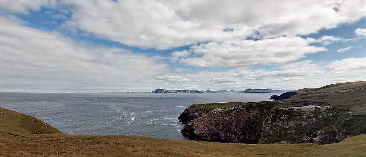
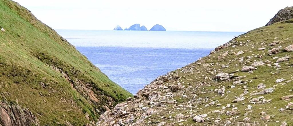
The spectacular loop hike opens onto breath-taking views of islands and sea cliffs jutting out of the waves of the Atlantic Ocean. Walking anticlockwise, keep an eye out on the sea for the Stags of Broad Haven archipelago. This cluster of five rock islands steeply rises above the waters to almost 100m in height. If you are super fit and way more adventurous than us, you could kayak out to the uninhabited and ungrazed islands – more info here. What an epic thing to do!
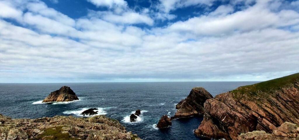
Gubastuckaun Sea-Stack, Llandavuck Island And Pigeon Rock
Somehow we managed to miss the sea-stack completely! Maybe we did not walk close enough to the ocean edge to see it. Anyhow, Llandavuck Island and Pigeon Rock did not disappoint. How beautiful is this?
Eagle Island
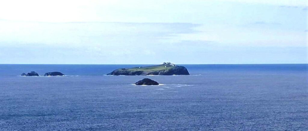
About half-way along the loop walk, you will get a fabulous view of Eagle Island. The buildings you may be able to make out are an 1830’s lighthouse. In fact, two lighthouses used to stand here, one in the East and one in the West of the island. They guided ships travelling around the Mullet Peninsula from Blacksod Bay to Broadhaven Bay. Lighthouse keepers served on the island until 1988 when the signalling mechanism became automated. Since then, Eagle Island is uninhabited. The one remaining lighthouse flashes three white flares every 15 seconds. You can read about the fascinating history of these lighthouses here.
EIRE 62 Sign
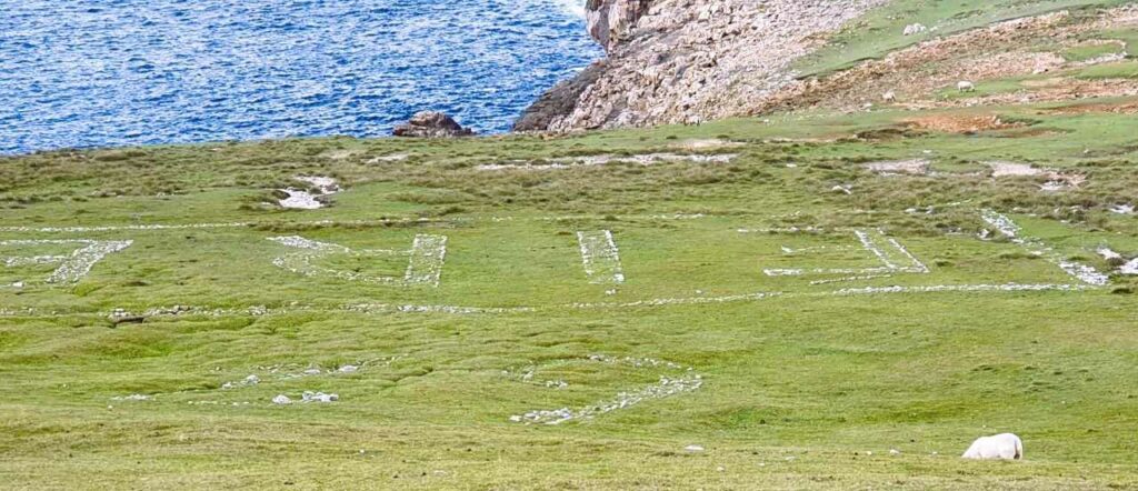
Rounding the north tip of Erris Head, you will come upon EIRE 62 sign laid out in white stone into the hillside. Éire stands for ‘Ireland’ in Gaelic. It is one of 80+ such aircraft navigational support signs constructed during World War II all around the Irish coast. The signs are the work of The Coastal Watch, whose task was to guard against a sea invasion of neutral Ireland. The Loop Walk also passes a former look out post built and used by The Coastal Watch. In recent years, many local communities renovated the EIRE signs. It reminded us that no country is indeed entirely neutral in a world conflict. Safety under these circumstances is an illusion.
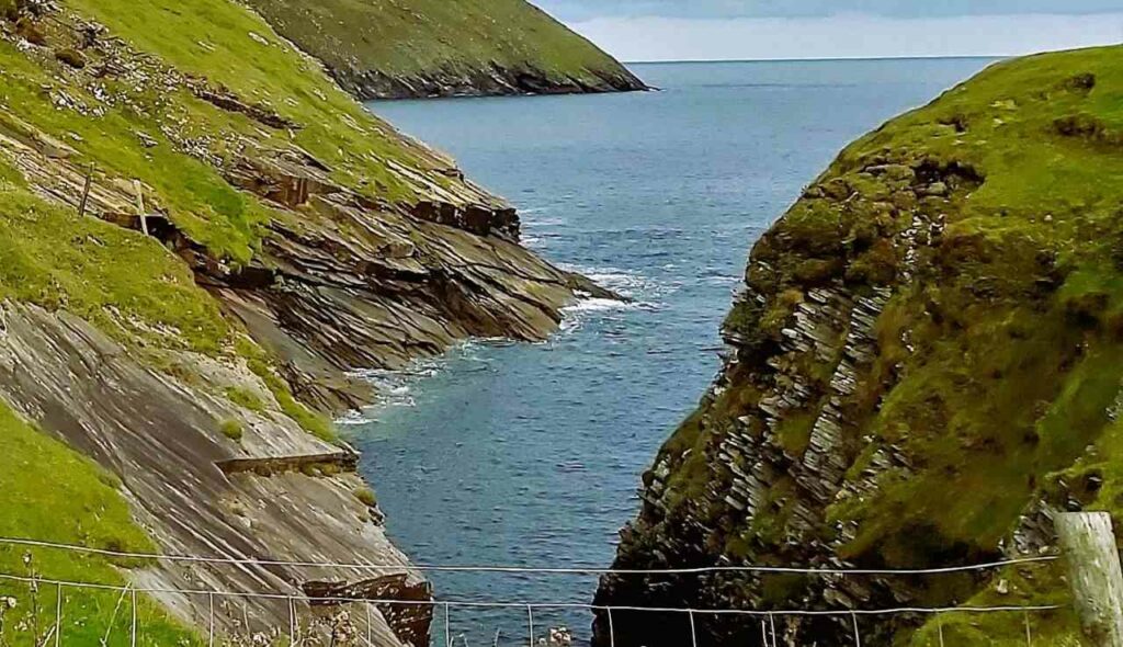
Ooghwee Inlet
The return leg of the walk leads past a narrow and steep inlet, which is definitely worth a stop and a peek. We lingered around here for a good while. Walking slightly uphill from there, you come to a concrete pillar. This serves as the Meteorological Service’s information gathering structure.
And you are back at the starting point. Let us know if you walked the Erris Head Loop Walk and what you thought.